TONEY’S BROOK TRAIL PROJECT
INTRODUCTION:
The project will cover the route of Toney’s Brook through the township and into Glen Ridge and Bloomfield. Each of 10 locations will have a interactive sign showing the map and location (you are here) and the history of the neighborhood, covering pre-colonial history, colonial times, the American Revolution, the Industrial Era, and contemporary times as appropriate. Each sign will have a scannable QR code connecting to our website to provide more detailed historical information about the project. The QR code will provide direct access to this information to anyone with a cell phone.
Although much of the history of Toney’s Brook has been documented by the Montclair History Center and local historians, this project aims to increase public awareness of the history of Toney’s Brook and of Montclair and other communities bordering the Brook in general by making this information accessible to a large audience in a simple way with the installation of the ten interactive signs in strategic locations. The project is partially funded by the Essex County Department of Parks and Recreation and Cultural Affairs and has the approval of the Township of Montclair.
![]()
![]()
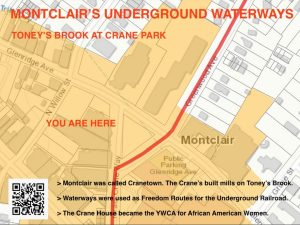
MONTCLAIR UNDERGROUND WATERWAYS
A. Location #1: TONEY’S BROOK AT CRANE PARK – Street Sign Design
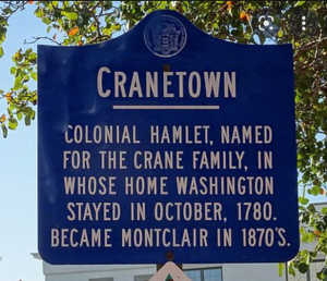
Montclair was once called Cranetown. Israel Crane built the Mills on
Toney’s Brook.
(Possibly a voice recording will be inserted here)
Visitors and people passing by will be able to listen or read this narrative after
they scan the QR in their smart phones:
 Narrative:
“Israel Crane was one of the first to utilize the immense waterpower of the Pacific falls near Paterson and directed there the second cotton mill. He controlled the waterpower on Tony brook and directed the first cotton mill on the stream which he afterwards sold to the Wilde family in the management of his extensive business interests. He displayed wonderful sagacity and great executive ability. At the same time, he gave encouragement to and promoted every new enterprise that gave promise of success. He did more to develop this region of country than any man before or since. He opened and developed an immense brownstone quarry in Newark, one of the largest in this part of the country, employing at times from 3 to 400 workers. He projected the Newark and Pompton Turnpike which opened a large extent of country thereby enhancing the value of farm property and affording the farmers better facilities for transporting their produce to the market.” – Source: History of Montclair Township by Henry Whittemore 1894.
The African American history connection:
Waterways were used as freedom routes for the Underground Railroad
Video click here:
![]()
https://www.fox5ny.com/news/underground-railroad-went-through-nj-
restaurant
The Crane House became the YWCA for African American Women in
Montclair.
https://montclairlocal.news/the-untold-history-of-women-at-montclairs-
historic-ywca/
![]()
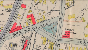
Cranetown Historic Plaque:
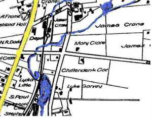
1857 MONTCLAIR MAP WITH WATERWAYS – Toney’s Brook and Mud Lake
1909 MONTCLAIR MAP – with Crane Park and the original site of the Israel
Crane House
Toney’s Brook Trail: The Glen and The Brook
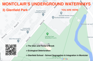 Narrative: A glen is a secluded narrow valley often created by the flow of a brook. Toney’s Brook is a tributary of the Second River in Essex County, New Jersey in the United States. Generally thought to be named for Anthony Oliff, a resident of West Orange (Newark in his time).
Toney’s Brook originates in Montclair northwest of the Upper Montclair railway station (originally north of the Montclair Presby Iris Garden), now with two branches, east and west of the elevated railroad tracks at Bellevue. In Montclair it is joined by two tributary streams, both originally also called Toney’s (one called Tunnel Brook, arising from the cliff near Claremont Ave.). In Montclair, Toney’s Brook runs through Anderson Park, Edgemont Memorial Park, Montclair HighSchool and Glenfield Park. In Glenfield Park, the brook continues southeast into Glen Ridge, where it flows through The Glen (the glen for which that borough is named). It then flows into Bloomfield and, in Watsessing Park, joins the Second River, a tributary of the Passaic River. Locally, brooks were used as freedom routes for fugitive enslaved people. The Second River led to the Morris Canal in Bloomfield that was a means of transportation for the Underground Railroad. Sounce: Wikipedia
Ecological deterioration:
Many roads have been built over the brook and in some places, it is covered up completely, canalized or culvertised. With the increase in the volume of water during storms in recent years the culvers reach their maximum capacity causing structural and material deterioration and pollution.
In the 19th and early 20th century, Toney’s Brook supported several mills, which produced lumber, beer, calico, brass fittings, and pasteboard boxes. Before ecological regulations, these mills discharged their waste into the natural waterways.
- Montclair’s Little Italy – the Italians in Montclair
https://youtu.be/f5Z9KH_Xe4E Italians in Montclair Video
https://montclairlocal.news/roads-throughout-montclair-flooded-its-bad-everywhere/ Flooding at Pine Street
https://baristanet.com/2017/03/montclair-minnie-a-lucey/
Social issues in the neighborhood:
- Glenfield School – School Segregation & Integration in Montclair. Follow these links:
https://www.montclair.k12.nj.us/district/magnet_system/historical_perspective
https://www.njspotlightnews.org/video/beyond-image-harmony-inequities- montclair-remain/
https://montclairlocal.news/report-montclairs-schools-reflect-community-diversity/
TONEY’S BROOK TRAIL:
4) Walnut Street
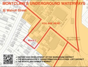
Narrative: History and Development Background (Township of Montclair)
The study area has been subject to a long history of redevelopment initiatives as indicated in the historic timeline below. The property was at onetime owned by the Township of Montclair and used for various municipal purposes. “Subject site” in the timeline below refers to the entirety of the block bounded by Erie Street, Label Street, Forest Street, and Oak Place.
1869: Samuel Crump relocates his printing business from New York City to the subject site.
1875: The firm of Crump & Everdell erect two factory buildings on the subject site. Crump dedicates the entire factory to printing labels for the then new business of consumer can & bottle labeling.
1877: The factory burns down on July 4th.
1877-1890: The factory buildings are immediately replaced with larger buildings and several more additions over time.
1888: Everdell leaves, and the company is renamed Samuel Crump Label Company.
1890: Crump sells the 200-employee company to Hinds & Ketchem, a Brooklyn company of former
employees controlled by Joseph Hinds & William Ketchem.
1891: United States Printing Company purchases the Hinds & Ketchem factory. The factory is one of the largest, if not the largest factory of its kind in the U.S. producing 9MM pounds of card & paper annually.
1910: New Jersey Coated Paper Company assume ownership of plant.
1928: Business is suspended at Label Street.
1929: The Township of Montclair acquires the subject site on July 29th for $150,000. The Township received a grant to demolish all buildings on the site aside from what remains today. At that time, the Township used it as a Department of Public Works site.
1930: Montclair Township proposes the Walnut Street Station Plaza Development Plan which is subsequently defeated in a public referendum.
1930-1963: The Montclair Poor Department moves to Label Street site and is renamed the Montclair Welfare Bureau.
1932: The site is the subject of an extremely contentious municipal election over the property purchase and its use and is considered by many as a white elephant akin to the Louisiana Purchase.
1935: A plan is created by the United States Department of Agriculture to rent the building to house a tree conservation workforce and as a base for 3,000 tree workers in Northern New Jersey and several New York counties. The plan fails to be implemented.
1937: The Township of Montclair starts demolition of the factory buildings, excluding the structure along Oak Place at Erie Street (4 Erie Street) whose mezzanine houses the Works Progress Administration sewing room. The Welfare Bureau Building at the corner of Label Street & Erie Street is also left standing.
1937: A $15,000 municipal building at Forest and Label Streets is designed, built, and leased to the State of New Jersey as a Motor Vehicle Inspection Station.
1938: The Montclair Housing Authority proposes a 163-unit Low-Cost Housing Neighborhood Project that includes the subject site and surrounding properties. The project fails to be implemented.
1942: The Erie Railroad Company prepares a site plan for the area surrounding the Walnut Street commuter lot (Block 3307, Lot 8). The blueprint shows a never-realized extension of Label Street across tracks to Montclair Avenue.
THE NEIGHBORHOOD’S TRANSFORMATION INTO A “Soho-like” LOFT DISTRICT
from https://baristanet.com/2018/01/random-walk-walnut-street-montclair-lovewhereyoulive/
Narrative by Carmel Loughman:
One beautiful spring Sunday, in the early afternoon, I took a walk of about a dozen blocks circling my Walnut Street neighborhood. Sauntering up Walnut Street, I snapped a picture of the blanket of bright red tulips on the corner of Grove Street. I passed by the energetic kids at Kaveny baseball field watched by their chatty, relaxed parents. I admired the soft grey bricks of the stately Deron School in its sylvan setting. At Erie Park, I watched the dog walkers tending their pit bulls and German shepherds. I eyed with a growling tummy the eateries clustered together around Frink Street. I circled the interesting modern building being constructed at the Forest Street intersection. I appreciated the new look of the old, repurposed Motor Vehicle inspection station. I cut through the empty Farmer’s Market site imagining when it is overflowing with produce and eager shoppers. I then went by the familiar stores on Grove Street, down Oxford to Walnut Crescent, and home.
TONEY’S BROOK TRAIL
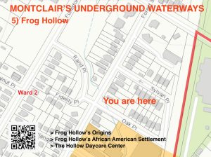
B. Frog Hollow Location – Street sign design
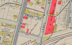
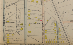
1909 Map of Montclair, Rand Park area near Frog Hollow location:
 Narrative:
Frog Hollow’s Origins
Dr. Watkins’ book, “Reminiscences of Montclair, As He Remembers From 1876” (pg. 47) “In 1876, Montclair was only a township, composed of farms which were practically just beginning to be cut up into smaller lots and have streets cut through to accommodate the newcomers. There were great fields and large old orchards around every place, as this had been a great apple country where each fall great quantities of cider were made and shipped all over the country. The principal place for cider mills was along Toney’s Brook where they would be operated by Waterpower. And at this time, there were the remains of several of them in different degrees of dissertation and dilapidation.
“The farms or open spaces were very general all over the township, with houses scattered around very sparsely. For instance, the entire district between Grove and Forrest Streets were farms with, as I remember, one field of rye and several old orchards and fields where cows were pasturing…. Between Forest Street and Park Street there were great open spaces of old orchards and then again west of Valley Road was all open country and east of Valley Road to Mountain Avenue the same conditions prevailed, and above Mountain Avenue, it was all forest…. What was known as Frog Hollow at William Street and Central Avenue, there was quite a community settlement right in the center of a section of fields.”
Frog Hollow’ African American Settlement
It is said that Frog Hollow’s African American Community dates back to the Revolutionary War period. The Hollow can be considered the wetlands area and flood zone of Toney’s Brook, from a branch opened when digging for a train tunnel at the Freed Slave House (James Howe property) uphill. The name originating from its swamp like characteristics. This land once owned primarily by various members of the Crane family, was dotted by the ruins of abandoned cider mills, and then acquired by the NY and Greenwood Lake Railway Company to
create a train line leading to a tunnel cut into the side of First Mountain. The tunnel’s test bore could have been a part of a “Freedom Route” for the Underground Railroad, from the Freed Slave House to the Crane House.
A Revolutionary War tunnel went underground 1.4 miles to the Davis Homestead on the Morris Canal in Bloomfield. Cutting into the mountain for the tunnel’s test bore increased the outletting of water into Toney’s Brook. Economic failure in 1873, as well as the abundance of water, caused the company to abandon the project and this swampy, non-marketable land was developed to house workers’ cottages. Many of these houses are still standing today.
The neighborhood was populated by African Americans immigrating from the south. European indentured immigrants also settled here, and together they began to create a community at Frog Hollow that provided services for the wealthy homeowners in Montclair. The brook was used for laundering as well as a pathway for workers to reach the Mill (now the site of Glenfield School)
The Hollow Daycare Center
Intrinsic to this tiny community was the Hollow Day Care Center, founded by Mother Lillie Walthall Connor, Montclair businesswoman/philanthropist and daughter of sharecroppers from Virginia. With funding from the Kennedy Project
she created a nonprofit organization that has provided after-school care for children from 6 to 13 for 45 years.
![]()
https://youtu.be/QMZ8lTHDrtU Video Narrative of Mother Lillie Walthall Connor
![]()
https://baristanet.com/2013/07/mother-lillie-connor-founder-of-historic-
montclair-hollow-day-care-center-died-this-morning/
TONEY’S BROOK TRAIL
C) Rand Park – Montclair High School Brook
1909 Map of Toney’s Brook at the Rand Park Site
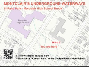 Toney’s Brook at Rand Park – Montclair’s “Central Park” at the George Inness High School.
George Inness’ influence on Central Park and Montclair is that they were designed like landscape paintings. In a panel discussion presentation held at the Montclair Art Museum, “Why Montclair is Montclair – The Role of Art and Architecture in the Twentieth Century”, Panelist Diane Lewis, Rome Prize recipient and professor at the Cooper Union School of Architecture, brought to light how Olmsted’s Central Park is conceived as a three-dimensional Hudson River Valley School painting. The Montclair High School Brook and Amphitheater are like a George Inness painting that intends to preserve the natural beauty of Montclair, much like NYC’s Central Park, inspired by Inness and designed by Olmsted.
The Montclair Municipal Arts Society engaged John Nolen, a student of the Olmsteds, to plan a town conceived to preserve the natural beauty emblematic of George Inness’ and other Montclair Artist Colony/Hudson River Valley painters’ works. According to Lewis, “This site of Montclair is architecture before the buildings. In the most ancient sense, like a Greek or Roman site, Montclair is a geographical god- or gods-given place. This distinguishes it from a lot of other kinds of settlements.”
In other words, Montclair’s physical location at the base of the First Watchung Mountain, with a series of views either west towards the bluff or east towards New York City, a cameo on the horizon, makes it a perfect and wholly unique setting for a picturesque town. “You have this amazing bluff, or cliff, or however you would like to call it,” Lewis continued, “and this elevation faces across an enormous span so there’s almost this mystical vision of Manhattan Island that floats in space as you look across. Now this is the fundamental architectural condition that makes this place, and it’s a unique Condition. George Inness’ influence on Central Park and Montclair is that they were designed like landscape paintings.”
![]()
https://youtu.be/YY6LZ06caC4 “Why Montclair is Montclair – The Role of Art
and Architecture in the Twentieth Century” video
Frank Gerard Godlewski, Architect and Montclair, NJ Historian
QUESTIONS ABOUT THE PROJECT? PLEASE CONTACT US AT: INFO@NEEARTH.ORG
![]()